Thursday, March 26, 2009

Chicago: End of the road

Last day of major driving, from St Louis to Chicago - initially along the backroads making up the old route 66 for a couple of hours, then the freeway into Chicago. Illinois countryside was very flat - flattest so far in crossing the great plains, but still pretty little towns - much more prosperous than in places like Oklahoma.

Finished the day with a drink in the bar on the 96th floor of the John Hancock Tower, looking down on Chicago

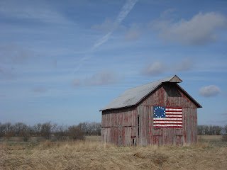
Patriotic barn on old Route 66... Main St, USA
The end of the raod - Lake Michigan in Chicago

Chicago skyline by day......


....and night


Tuesday, March 24, 2009

Day 8: Springfield to St Louis

Drove across Missouri to St Louis - Missouri was mainly gentle rolling countryside. St Louis is the biggest city since I left Los Angeles and has lots of historical buildings as well as a centrally located park, all of which make it feel like a smaller version of New York or Chicago. The key tourist sructure is the Gateway Arch, next to the Missisippi River.

Gateway Arch, from the bottom... ...and the view from the top - to get to the top you have to get into little 5 seater capsules, a bit like you might have on a ferris wheel, and then these are pulled to the top.


The Eads Bridge over the Missisippi. When completed in 1874, the Eads Bridge was the longest arch bridge in the world.


Visited the St Louis Zoo - so did not have to come face to face with a wild Grizzly Bear....

or an Amur Leopard!


Monday, March 23, 2009

Day 7 - From Tulsa to Springfield, Missouri, via the Ozarks

Today started with a drive along the old route 66 through Oklahoma and Kansas to Joplin, Missouri, before leaving route 66 to go down to the Ozark Mountains of Arkansas. The Ozark's are not the tallest of mountains, but did not get proper roads until about 50 years ago and even now feel a bit cut off - but they do include the town of Eureka Springs (which although it sounds like it should be in a film or a sitcom) is in fact a beautifully preserved Victorian spa town.

The coming of the interstate freeway system was not good for all businesses.....
a 1930's bridge on route 66 in Kansas

Main Street in Eureka Springs


Eureka Springs


Bridge in the Ozark Mountains


Sunday, March 22, 2009

Day 6 - Amarillo to Tulsa, via Oklahoma City

Spent most of the day following the path of Route 66 (as opposed to my diversions on previous days) - that meant the freeway from Amarillo to Oklahoma city then the old route 66 through the Oklahoma countryside and small towns to Tulsa. I was expecting Oklahoma to be flat plains, but in fact it was more gently rolling hills, which, given it was springtime, in places looked almost like England (but with fewer houses!)

1930s petrol station in Shamrock, Texas - I'm sure that Disney had something similar in "Cars"

Memorial to the Oklahoma City bombing


Detail of a huge glas sculpture in the foyer of the Oklahome Art Museum


Tulsa cityscape - what I don't understand is why both Oklahoma City and Tulsa had large empty building lots, still with remnants of driveways etc. very close to their downtown areas - in other cities these would have been developed.


Saturday, March 21, 2009

Day 5 - Part 2 - onwards to Amarillo

After lunch, I drove across Western New Mexico to Amarillo, stopping just outside Amarillo to visit "Cadillac Ranch" - 10 half buried Cadillacs in the middle of knowhere, covered in graffiti.


Day 5: Santa Fe to Amarillo, via Taos

Onto day 5 of the trip - and by the end of the day I was at least half way through, reaching Amarillo, a city that is most famous for having the largest cattle market in the world (and i thought that was the Bigg Market in Newcastle on a Saturday night!).
This was a day that had a lot of desert driving through New Mexico and some mountains - crossing the Sangre de Cristo mountains - all beautiful, but without the outstanding moments of previous days.

The day started in Santa Fe, and then drove up to Taos via the Rio Grande gorge. Taos itself was a pretty little new Mexican town. Just south of Taos itself was Rancho de Taos, including an adobe church from Spanish times.


I stopped for lunch at Las Vegas, New Mexico - not the famous one (as you can see from main street below), but a historic town that seemingly stopped building in about 1910.


Friday, March 20, 2009

Day 4: Santa Fe

Final stop for the day was Santa Fe, upmarket resort town and one of the oldest cities in the States, thanks to its Spanish ancestry. The Palace of the Governers still stands on the plaza in the centre of town, surrounded by art galleries - over 250 in all - in fact, there is not much else in the streets around the Plaza other than galleries, restuarants and a few high class hotels - great if you suddenly need a painting of an Indian Brave or some "interesting" modern art.
Actually, I was a bit dissapointed - perhaps because Santa Fe has an almost iconic quality, but getting there and realising it is a bit like a Disneyland for rich grown ups was not what I was expecting.
However, it did have the Georgia O'Keeffe museum, full of paintings of flowers and skulls which was, fortuitously, free entry on a Friday evening!
Here is an example of one of Santa Fe's elegant courtyards A funky shop (selling tourist tack)
The Palace of the Governors - built in about 1600, this is the oldest public building in the US (and quite a nice little museum too)


The Museum of Fine Art, in a typical adobe style.


Day 4 continued: Driving from El Morro into Albuquerque

After leaving El Morro I headed towards Albuquerque - on the way passing the Continental Divide - from now on any rivers flow ultimately into the Atlantic whereas previously any water would eventually end up in the Pacific
Back on route 66 and only in America would you find a super-fast Casino.....

Albuquerque Old Town is a small oasis of original Spanish buildings amidst the sprawl of modern Albuquerque (although parts of downtown had a nice 1920s feel). anyway, this is the original Spanish church

Chiles drying on a rack..


And part of the original plaza


El Morro - part 2

I decided to follow the path to the top of the Mesa - a climb of about 250 vertical feet (but on a nice path with steps). Sadly, doing this at 7200 ft altitude to begin with, showed why athletes do altitude training 9or maybe i'm just a bit unfit!)


On top of the Mesa are the ruins of an Anasazi pueblo - built on the top for defence - i also learnt that "Anasazi" is actually Navajo for "ancient enemies". What was that quote about history being written by the victors.


Day 4 Part 1: El Morro National Monument


South of Gallup and in the middle of nowhere is El Morro, which is famous for a pool of water that is available all year round, which was the only reliable source of water for at least 30 miles - as people visited the pool, they decided to leave inscriptions in the rocks - starting with petroglyphs from pre-1600 through to the Spaniards (including inscriptions from the first expedition in 1603) through to colonising Americans in the 1800's


End of day 3 (at last!) El Rancho hotel - Gallup New mexico

Over 1000 miles done (which means quite a lot of driving), but becuase of the detours, only about a quarter of the way along route 66 - still a long way to go!

I stayed last night in the El Rancho hotel in Gallup, New Mexico. It is a bit OTT, built in the 1930s as a place for film stars to stay, when filming in the nearby desert. I had the "Robert Mitchum" room!


Canyon de Chelly - continued

Apparently you can do 4x4 trips with the Navajo into the Canyon - i did not have time, but if you look on the canyon floor you can see the cars In the shadow to the bottom right of the previous picture are some more ruins.....

This is Spider Rock - according to Navajo legend the Spider Woman lives on the tip of the taller spire.


More arty canyon photos